
Wegenkaart - landkaart Kongo - Congo | IGN - Institut Géographique National (3282118501519)
Congo (Brazzaville)
- ISBN / CODE: 3282118501519
- Schaal: 1:1000000
- Uitgever: IGN - Institut Géographique National
- Soort: Wegenkaart
- Serie: Découverte du Monde
- Taal: Frans
- Uitvoering: -
- Bindwijze: -
- Schrijf als eerste een review
-
€ 11,75
Uitverkocht, nooit meer leverbaar
Beschrijving
Goede overzichtskaart van het Franse Cartografisch Instituut. Met autoroutes en stadsplattegronden van de belangrijkste steden.
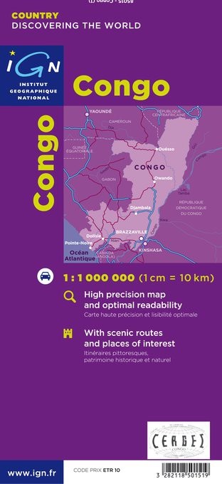
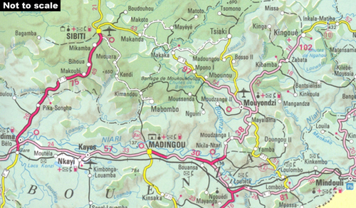
Congo (Brazaville) on a road map from the IGN in Paris, with relief shading and colouring/graphics indicating different types of vegetaion and terrain: forest, grassland, marches, areas liable to flooding. Road and rail connections are shown, with a separate distance table between main centres of population. A large diagram shows the administrative divisions of the country. Latitude and longitude are shown in the margins at 1 degree intervals. The legend is in French only.
Reviews
Geen reviews gevonden voor dit product.
Schrijf een review
Graag horen wij wat u van dit artikel vindt. Vindt u het goed, leuk, mooi, slecht, lelijk, onbruikbaar of erg handig: schrijf gerust alles op! Het is niet alleen leuk om te doen maar u informeert andere klanten er ook nog mee!
Ook interessant voor afrika/kongo
-

Natuurgids Africa Wildlife an introd
€ 9,95Natuurgidsen Angola -

Wegenkaart - landkaart Kongo - Congo
€ 17,95Wegenkaarten Demokratische Republiek Kongo -

Vogelgids - Natuurgids Africa Birds
€ 9,95Natuurgidsen Algerije -
 | Bradt Travel Guides")
Reisgids Congo: Democratic Republic
€ 23,95Reisgidsen Demokratische Republiek Kongo -

Natuurgids African Animal Tracks | W
€ 9,95Natuurgidsen Kenia