
Wandkaarten van landen - Europa
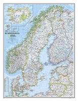 Wandkaart Scandinavië en Ijsland, 60 x 77 cm | National Geographic
National Geographic Wall Maps offer a special glimpse into current and historical events, and they inform about the world and environment. Offered in a variety of styles and formats, these …
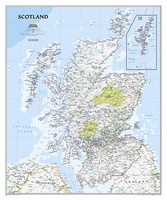 Wandkaart Schotland, 76 x 91 cm | National Geographic
This new map of Scotland, features our rich, antique-inspired Executive style. This beautiful map includes thousands of place names, accurate political boundaries, national parks, archeological sites, and major infrastructure networks …
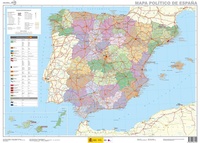
★★★★★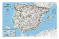 Wandkaart Spain - Spanje & Portugal 83 x 55 cm | National Geographic
This classic-style map of Spain and Portugal shows political boundaries, major highways and roads, cities and towns, airports and other geographic details. Thousands of place-names and exact borders are carefully …
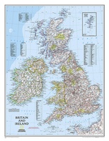 Wandkaart Britain and Ireland - Groot Brittannië en Ierland, 60 x 76 cm | National Geographic
This classic-style map of England and Wales shows political boundaries, major highways and roads, cities and towns, airports, and other geographic details. Thousands of place-names and exact borders are carefully …
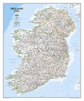 Wandkaart Ireland – Ierland, 76 x 91 cm | National Geographic
National Geographic Maps' new Ireland wall map is one of the most authoritative maps yet published of the Emerald Isle. Of the nearly 1,000 place-names shown on this map, all …
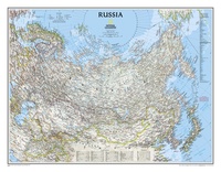 Wandkaart Russia – Rusland, 77 x 60 cm | National Geographic
Our classic wall map of Russia and the independent states of the former Soviet Union shows thousands of place names, roadways, political boundaries, bodies of water, airports, and many other …
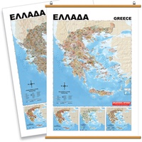 Wandkaart Griekenland Natuurkundig, 70 x 100 cm | Orama
Mooie natuurkundige kaart van Griekenland met namen in het Grieks.
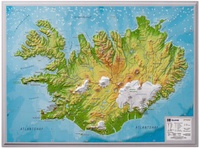 Wandkaart - Reliëfkaart IJsland met voelbaar 3D reliëf 42 x 30 cm | GeoRelief
Prachtig vormgegeven wandkaart van IIsland met reliëf. Uitgevoerd in stevig kunststof is IJsland vanzelfsprekend een land dat zich bij uitstek leent voor een 3D kaart: zo komen de bergmassieven, maar …
★★★★★ Wandkaart Spanje, 70 x 50 cm | CNIG - Instituto Geográfico Nacional
Administrative provinces of Spain shown in bright colours on a wall map at 1:2,250,000, size 70 x 50cm (27.5" x 20" approx), from IGN/CNIG - the country’s civilian survey organization, …
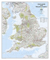 Wandkaart Engeland en Wales, 76 x 92 cm | National Geographic
This classic-style map of England and Wales shows political boundaries, major highways and roads, cities and towns, airports, and other geographic details. Thousands of place-names and exact borders are carefully …
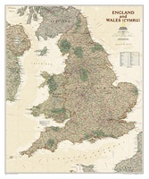 Wandkaart Engeland en Wales, antiek, 76 x 91 cm | National Geographic
This earth-toned, executive-style map of England and Wales shows political boundaries, major highways and roads, cities and towns, airports, and other geographic details. Thousands of place-names and exact borders are …
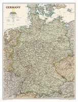 Wandkaart Duitsland, antiek, 60 x 77 cm | National Geographic
Complete political actual detail of Germany - country boundaries, roads and cities, airports, bodies of water, and other geographic details in antique style.
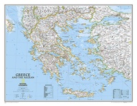 Wandkaart Greece – Griekenland, 77 x 60 cm | National Geographic
Decoratieve wandkaart van Griekenland. Naast de mooie kleuren staan er bijzonder veel plaatsen op vermeld. The classic National Geographic wall map of Greece shows this beautiful area in uncompromisingly …
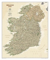 Wandkaart Ierland, antiek, 76 x 92 cm | National Geographic
National Geographic Maps' new Ireland wall map is one of the most authoritative maps yet published of the Emerald Isle. Of the nearly 1,000 place-names shown on this map, all …
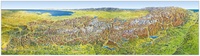 Wandkaart Das Grosse Alpen - panorama, sommer / zomer uitgave | MairDumont
Wandkaart van de hele Alpen van oost naar west met de namen van de bergtoppen. Mooie uitvoering om in details alle valleien en bergruggen te zien. De mogelijkheden om te …
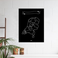 Wandkaart Krijtbord Nederland Woody Map Chalkboard | Miss Wood
Naast de bekende Woody Map prikborden komt het Spaanse merk Miss Wood nu met een zwarte met krijt beschrijfbare kleeffolie waarop Nederland staat afgebeeld. Er worden 6 krijtjes in verschillende …
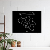 Wandkaart Krijtbord België Woody Map Chalkboard | Miss Wood
Naast de bekende Woody Map prikborden komt het Spaanse merk Miss Wood nu met een zwarte met krijt beschrijfbare kleeffolie waarop Nederland staat afgebeeld. Er worden 6 krijtjes in verschillende …
★★★★★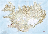 Wandkaart IJsland 157,5 x 112 cm | Ferdakort
Prachtige grote wandkaart van IJsland: het is de ongevouwen versie van een grote wegenkaart met heel veel topografische details. Hoogwaardige kaart van het land met mooi kleurgebrukk, waarbij bijvoorbeeld hoogtes, …
 Wandkaart Belgie & Luxemburg 125 x 99 cm | Hallwag
Mooie geplastificeerde wandkaart van België en Luxemburg.
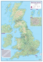 Wandkaart Engeland - British Isles roadplanning wall map, 84 X 119 cm | Maps International
Routeplanner map from Maps International's selection of British Isles maps. Routeplanning map details: British Isles routeplanning map shows the motorways, major roads and transport hubs such as airports and …
Laatste reviews

Ideale schaal waar ook de kleinere wegen duidelijk zijn aangegeven. Beschrijving op website is correct.
★★★★★ door Peter 16 mei 2024 | Heeft dit artikel gekocht
Overzichtelijke kaart. Niks op aan te merken.
★★★★★ door Bastiaan de Leeuw 16 mei 2024 | Heeft dit artikel gekocht
Fijne overzichtelijke kaart. Niet veel op aan te merken!
★★★★★ door Bastiaan de Leeuw 16 mei 2024 | Heeft dit artikel gekocht
Voor het wandelen niet heel geschikt. Door het kleurgebruik zit er weinig contrast in en komt het erg donker over. Wat ingewikkeld oriënteren. Maar je …
★★★★★ door Bastiaan de Leeuw 16 mei 2024 | Heeft dit artikel gekocht