Winkelwagen
Geen items in winkelwagen
Ga naar winkelwagen
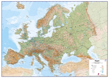
Wandkaart Europa Natuurkundig, 135 x 98 cm | Maps International (9781910378069)
Papieren versie
- ISBN / CODE: 9781910378069
- Editie: 10-01-2022
- Aantal blz.: 1
- Schaal: 1:4300000
- Uitgever: Maps International
- Soort: Wandkaart van continenten
- Taal: Engels
- Hoogte: 99.0 cm
- Breedte: 136.0 cm
- Gewicht: 287.0 g
- Bindwijze: -
- Uitvoering: Papier
- Schrijf als eerste een review
-
€ 24,95
Leverbaar in 3 - 5 werkdagen in huis in Nederland Levertijd Belgie
Gratis verzending in Nederland vanaf €35,-
Beschrijving
Maps International's large physical wall map of Europe is one of the finest money can buy.
European Map details: Our large physical wall map of Europe features the natural terrain of the land, with countries marked and international borders shown. The map's key helps to identify the land elevation and water depth. This large European physical wall map also contains city population detail, national capitals and all the major towns and cities in Europe.
Map uses: As with most of our maps, the large physical wall map of Europe, is available in a range of finishes making it suitable for a variety of locations. Major motorways and transport lines are shown on this European wall map making it an ideal map for planning and logistics
Dit product heeft meerdere varianten:


