Categorieën
- Nieuwe artikelen
- Boeken
-
Kaarten
- Camperkaarten
- Educatieve kaarten
- Fietskaarten
- Fietsknooppuntenkaarten
- Historische Kaarten
- Pelgrimsroutes (kaarten)
- Spoorwegenkaarten
- Stadsplattegronden
- Toerskikaarten
- Topografische kaarten
- Wandelatlassen
- Wandelkaarten
- Wandelknooppuntenkaarten
- Waterkaarten
- Wegenatlassen
-
Wegenkaarten
- Afrika
- Azië
-
Europa
- Albanië
- Andorra
- Armenië
- Azerbeidzjan
- Belarus - Witrusland
- België
- Bosnië - Hercegovina
- Bulgarije
- Cyprus
- Denemarken
- Duitsland
- Engeland
- Estland
- Faroer
- Finland
-
Frankrijk
- Picardie - Noordwest Frankrijk
- Hauts-de-France
- Grand-Est
- Champagne - Ardennen
- Normandië
- Bretagne
- Pays de la Loire
- Dordogne - Limousin
- Franse Atlantische Kust - Nouvelle-Aquitaine
- Aquitaine
- Limousin
- Poitou-Charentes
- Vogezen - Elzas - Lotharingen
- Île-de-France
- Bourgogne - Franche-Comté
- Franche-Comté
- Bourgondië
- Auvergne - Rhône-Alpes
- Auvergne
- Rhône-Alpes
- Franse Alpen
- Alpen - Mont Blanc - Haute Savoie
- Alpen - Vanoise - Savoie
- Alpen - Vaucluse - Drome - Vercors
- Pyreneeën
- Occitanie
- Languedoc - Rousillon
- Cevennen
- Midi-Pyrénées
- Centre - Val de Loire
- Provence - Alpes-Côte d’Azur
- Cote d'Azur - Franse Riviera
- Provence
- Corsica
- Lyon
- Parijs
- Rennes
- Straatsburg
- Georgië
- Griekenland
- Groenland
- Hongarije
- IJsland
- Ierland
- Italië
- Kosovo
- Kroatië
- Letland
- Liechtenstein
- Litouwen
- Luxemburg
- Malta
- Moldavië
- Monaco
- Montenegro
- Nederland
- Noord-Ierland
- Noord-Macedonië
- Noorwegen
- Oekraïne
- Oostenrijk
- Polen
- Portugal
- Roemenië
- Rusland
- Scandinavië
- Schotland
- Servië
- Slovenië
- Slowakije
- Spanje
- Tsjechië
- Turkije
- Vaticaanstad
- Zweden
- Zwitserland
- Midden-Amerika
- Midden-Oosten
- Noord-Amerika
- Oceanië
- Wereld
- Zuid-Amerika
- Wintersportkaarten
- Opruiming
- Puzzels
- Travel Gadgets
- Wandkaarten
- Wereldbollen
Veilig online betalen
Betaal veilig via uw eigen bankomgeving
- U bent hier:
- Home
- Europa
- Frankrijk
- Alpen - Mont Blanc - Haute Savoie
- Kaarten
- Wegenkaarten
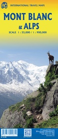
Wegenkaart - landkaart Mont Blanc & Alpen | ITMB (9781771294812)
- ISBN / CODE: 9781771294812
- Editie: 01-01-2023
- Druk: 1
- Aantal blz.: 1
- Schaal: 1:55000
- Uitgever: ITMB
- Soort: Wegenkaart
- Taal: Engels
- Hoogte: 25.0 cm
- Breedte: 10.0 cm
- Gewicht: 55.0 g
- Bindwijze: -
- Uitvoering: Papier
- Schrijf als eerste een review
-
€ 14,95
Op voorraad. Binnen 2 - 3 werkdagen in huis in Belgie Levertijd Nederland Voor 17.00 uur op werkdagen besteld, binnen 1 tot 2 werkdagen in huis in Nederland Levertijd Belgie
Gratis verzending in Nederland vanaf €35,-
- Afbeeldingen
- Inkijkexemplaar
Beschrijving
Reviews
Geen reviews gevonden voor dit product.
Schrijf een review
Graag horen wij wat u van dit artikel vindt. Vindt u het goed, leuk, mooi, slecht, lelijk, onbruikbaar of erg handig: schrijf gerust alles op! Het is niet alleen leuk om te doen maar u informeert andere klanten er ook nog mee!
Ook interessant voor europa/frankrijk/mtblanc-savoie
-

Tourskigids Skitourenführer Mont Bla
€ 18,50Tourskigidsen Alpen - Mont Blanc - Haute Savoie -

Wandelkaart 272T St. Maurice | Swiss
€ 26,95Wandelkaarten Haute-Savoie -

Wandelgids Tour du Mont Blanc - Hutt
€ 18,95Wandelgidsen Alpen - Mont Blanc - Haute Savoie -

Reisgids Savoie Mont Blanc (franstal
€ 16,50Reisgidsen Alpen - Mont Blanc - Haute Savoie -

Fietskaart - Topografische kaart - W
€ 15,95Fietskaarten Haute-Savoie


