Mandje Tel: +31503126950 Menu
Winkelwagen
Geen items in winkelwagen
Ga naar winkelwagen

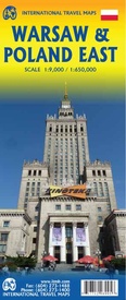
Wegenkaart - landkaart - Stadsplattegrond Poland east - Warsaw, Oost Polen en Warschau | ITMB (9781771298995)

  • ISBN / CODE: 9781771298995
  • Editie: 25-03-2018
  • Druk: 2
  • Aantal blz.: 1
  • Schaal: 1:9000
  • Uitgever: ITMB
  • Soort: Stadsplattegrond, Wegenkaart
  • Taal: Engels
  • Hoogte: 25.0 cm
  • Breedte: 10.0 cm
  • Gewicht: 52.0 g
  • Bindwijze: -
  • Uitvoering: Papier
  • Schrijf als eerste een review
  • 13,95

    Leverbaar in 3 - 5 werkdagen in huis in Belgie Levertijd Nederland Leverbaar in 3 - 5 werkdagen in huis in Nederland Levertijd Belgie

    Gratis verzending in Nederland vanaf €35,-

Beschrijving

ITMB wegenkaarten en wandelkaarten kenmerken zich door het kleurgebruik waarbij zo de nadruk wordt gelegd op de natuurkundige aspecten van het land of de streek. Het soort landschap en de hoogte worden hierdoor zeer duidelijk zichtbaar. Natuurlijk vind je ook de 'gewone' zaken als wegennet, spoorwegen, vliegvelden, ferrys, toeristische bezienswaardigheden en nationale parken er op terug.. Vaak - maar niet op alle kaarten - staat op de achterzijde een stadsplattegrond van hoofdstad of belangrijkste stad in de regio. 

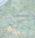
Voorzijde: Oost Polen shcaal 1:650.000

Achterzijde: Warschau, schaal 1:9.000

This is, at the same time, our second edition updated map of Warsaw and a brand new title for ITMB, in that we have added a regional map of the eastern half of Poland to the second side of the map. This gives the end user two maps for the price of one by combining the many attractions of the city with its surrounding countryside. Anyone with a small amount of historical knowledge knows that Warsaw was largely destroyed during World War II. Many historic cities suffered this fate; in the case of Warsaw, the historic ‘old town’ was re-built more or less as it had been, with some road widenings changing things, and the rest of the city was re-created as a post-war urban area. The ‘old town’ is actually quite compact, so is shown in detail on an inset map, as is the greater Warsaw urban area The urban map shows rail and metro lines/stations, tram lines, churches, theatres, the enormous Soviet-era cultural centre, hotels etc. The regional map covers a very large portion of eastern Poland, from the eastern borders to Lodz, and includes the roads leading to Krakow and Gdansk; altogether, a perfect map for those using Warsaw as a base and exploring the hinterland on short trips.
 
Legend Includes:
Highway, Railway, Other Roads, Motorway, Airports, Distance in km, Border Crossing, Ferry, Warsaw Subway, Tram, Commuter, Pedestrian Zone, National Park, River, Lake, Cities, Point of interest, Camp site, Mining, Museum, World Heritage, Shopping Centre, Cinema etc.

Reviews

Geen reviews gevonden voor dit product.

Schrijf een review

Graag horen wij wat u van dit artikel vindt. Vindt u het goed, leuk, mooi, slecht, lelijk, onbruikbaar of erg handig: schrijf gerust alles op! Het is niet alleen leuk om te doen maar u informeert andere klanten er ook nog mee!