
Engeland
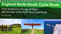 Fietsgids England North - South Cycle Route | EOS Cycling Holidays Ltd
This guidebook allows you to cycle from the Scottish border across England to the Isle of Wight, all via continuous traffic-calmed routes. The book also features the best of the …
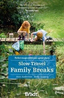 Reisgids Slow Travel Family Breaks | Bradt Travel Guides
Een bijzondere serie van Bradt guides. Met veel aandacht voor kleine details die je niet gauw elders zult vinden. Naast de beschrijvende informatie vind je ook een schat aan praktische …
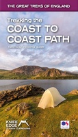 Wandelgids Trekking the Coast to Coast Path | Knife Edge Outdoor
The definitive two-way guide to the Coast to Coast Path: both eastbound and westbound routes are described in full. Real Maps: Full Ordnance Survey mapping inside (1:25,000). All accommodation is …
★★★★★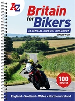 Wegenatlas Britain for Bikers | Voor Motoren | A-Z Map Company
Discover the best biking routes around Great Britain and Northern Ireland. Your essential rideout roadbook covering the best biking routes around Great Britain and Northern Ireland, including short trips and …
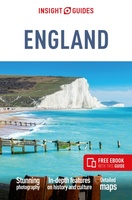 Reisgids England | Insight Guides
Een rijk geillustreerde reisgids met diepgaande teksten: één van de beste reisgidsen die er bestaan. Eerste deel bestaat uit een beschrijving van de unieke aspecten van de regio, daarna een …
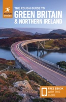 Reisgids Green Britain & Northern Ireland | Rough Guides
Een kleinere versie van de grotere versies van de Rough Guides. Als altijd weer vol met goede informatie over cultuur en praktische zaken. Achterin kleine plattegronden. Practical travel guide …
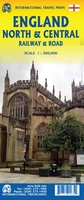 Spoorwegenkaart England North and Central Rail and Road | ITMB
This is a new title for ITMB, and continues our expanded coverage of the United Kingdom. Many publishers carry a map of Great Britain (or of the UK), and a …
 Wandelgids Walking The End to End Trail | Cicerone
Een droomroute voor velen: helemaal van het zuidelijkste puntje van Engeland naar het noordelijkste puntje van Schotland, zo'n slordige 1956 km door fabelachtig mooie afwisselende landschappen. Zeer gedetailleerd beschreven met …
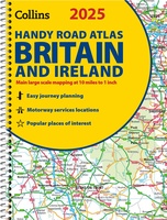 Wegenatlas 2025 Collins Handy Road Atlas Britain and Ireland | Collins
Handzame A5 wegenatlas van Engeland, Wales, Schotland en Ierland met register en stadsplattegronden This easy-to-use, handy A5 sized road atlas with popular lie-flat spiral binding features extremely clear route planning …
★★★★★ Reisgids Culture Smart! Britain - Groot Brittannië | Kuperard
De Cultuur Bewust!-gids geeft toeristen en zakenlieden belangrijke informatie met betrekking tot de cultuur van alledag in het land van bestemming. Anders dan in de gebruikelijke reisgidsen wordt de lezer …
 Wegenatlas Essential Road Atlas Britain 2025 | A4 | Ringband | Collins
This A4 road atlas with lie-flat spiral binding provides clear and detailed road mapping for England, Wales and Southern Scotland at a scale of 3.2 miles to 1 inch (1:200,000). …
 Campinggids - Campergids - Reisgids FKK Reiseführer Europa 2024 | Drei Brunnen Verlag
Reisgids voor naturisten met oa naturisme campings, terreinen, naaktzwemmen en naaktstranden door Europa met beschrijvingen, kaarten en adressen in Nederland, Belgie, Luxemburg, Oostenrijk, Zwitserland, Tsjechie, Duitsland, Denemarken, Spanje, Portugal, Frankrijk, …
★★★★★ Campergids Take the Slow Road Engeland en Wales | Spectrum
Snel rijden? Echt niet! Met je voet op het gaspedaal door het landschap racen is niet meer van deze tijd. Vergeet het gehaaste leven, rustig rondtrekken is de nieuwe manier …
★★★★★ Reisgids Wild Swimming Britain | Wild Things Publishing
The all-new bumper second edition of the best-selling Wild Swimming photo guide is now fully revised and expanded to include 150 NEW amazing wild swimming locations (almost 400 in total), …
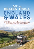 Campergids Off the Beaten Track: England and Wales | Bloomsbury
England and Wales might feel familiar to many, but there are countless hidden idylls and remote wildernesses to discover amongst the soaring passes, spectacular coastlines and boundless moorlands. For many, …
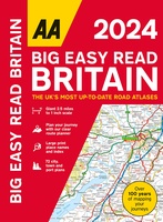 Wegenatlas Big Easy Read Britain 2024 | A3 | Ringband | AA Publishing
AA Publishing brings you the UK’s most up-to-date road atlases Over 100 years of mapping your journeys • Giant scale mapping at 2.5 miles to 1 inch = 1:25,000 • …
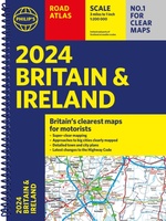 Wegenatlas Road Atlas Britain and Ireland 2024 | Philip's Maps
Let op! Ierland en een gedeelte van Schotland hebben een andere schaal dan de rest van de atlas. PHILIP'S - Market leaders and No. 1 in the UK for …
★★★★★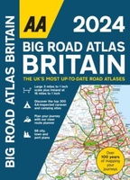 Wegenatlas Big Road Atlas Britain 2025 - A3 | Ringband | AA Publishing
This best-selling A3 format atlas is available in two binding styles; paperback and spiral bound. Up-to-date mapping from the experts at the AA this atlas has large 3 miles to …
★★★★★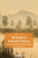 Reisgids Slow Travel Britain's Sacred Places | Bradt Travel Guides
Een bijzondere serie van Bradt guides, waarin een gedeelte van Engeland uitgebreid beschreven wordt. Met veelv aandacht voor kleine details die je niet ao gauw elders zult vinden. Naast de …
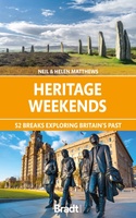 Reisgids Heritage Weekends | Bradt Travel Guides
History and heritage are among Britain’s greatest passions. Travel writers and historians Helen and Neil Matthews have selected 52 places that are wonderful examples of natural, architectural, industrial or cultural …
Laatste reviews

Aan twee kanten bedrukt met hetzelfde gebied, de ene kant gaf wandelingen weer, de andere kant mountainbikeroutes. Ruim een week vóór de wandelvakantie gekocht, een …
★★★★★ door elly stolwijk 04 december 2024 | Heeft dit artikel gekocht
Deze kaarten gebruik ik om mooie wandelingen uit te zetten, die ik dan met mijn liefste meisje beloop. Dank u wel voor de snelle adequate …
★★★★★ door Jacques Marks 03 december 2024 | Heeft dit artikel gekocht
Ook ik ben een zwerver, maar gelukkig niet dakloos. Deze kaarten gebruik ik om mooie wandelingen uit te zetten, die ik dan met mijn liefste …
★★★★★ door Jacques Marks 03 december 2024 | Heeft dit artikel gekocht
Perfect👍
★★★★★ door Wilma & Mari 03 december 2024 | Heeft dit artikel gekocht